- Home
- Services
- 3D Mapping
3D Mapping & GPR Surveys
Need a PAS 128 Compliant GPR Survey?
Sectors We Serve
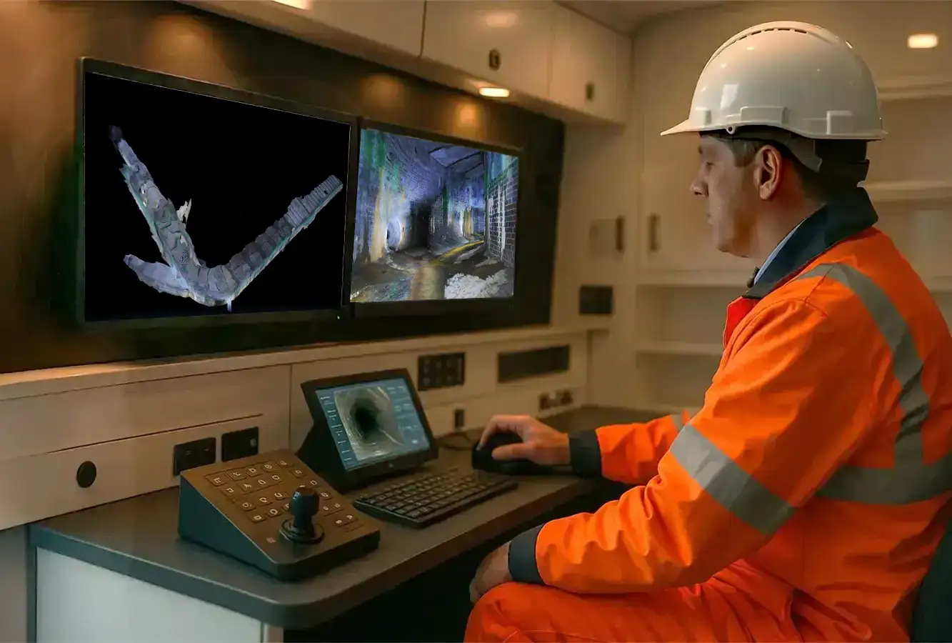
3D Mapping for Underground Infrastructure
Understanding what lies beneath the surface is critical for safe construction. Civil Connect provides Tier 1 underground utilities mapping, combining GPR (Ground Penetrating Radar) and Electromagnetic Location (EML) to create precise 3D mapping of your site’s subsurface.
Traditional 2D plans are often outdated or inaccurate. Our 3D solutions verify the exact position and depth of all buried assets—Gas, Electric, Water, and Telecoms—delivering a digital twin that integrates seamlessly into your BIM (Building Information Modelling) workflow.
What is an Environmental Risk Assessment?
We are proud to introduce our latest cutting-edge service: 3D Mapping for Drain Sewers and Water Infrastructure. Leveraging advanced technology and innovative techniques, this service enables comprehensive, accurate, and efficient mapping of underground systems to support both maintenance and future planning needs.
Our GPR Survey Capabilities
We use state-of-the-art detection technology to locate targets that standard surveys miss.
PAS 128 Utility Surveys: We adhere strictly to the PAS 128 standard, the UK benchmark for utility detection.
- Ground Penetrating Radar (GPR): Our GPR mapping units scan the ground to detect non-metallic pipes (plastic water mains, clay drainage) and identify voids or buried structures.
- Electromagnetic Location (EML): We trace conductive utilities like power cables and metallic pipes to verify their route and depth.
3D Project Mapping & BIM Output: We don’t just spray paint lines on the ground. We capture data to create a topographical 3d map of the subsurface.
- Revit & CAD Models: We convert raw survey data into fully layered 3D CAD or Revit models, allowing your architects to “see” the utilities relative to the proposed building foundations.
- Clash Detection: By modelling utilities in 3D, we help you identify clashes (e.g., a pile driven through a gas main) before construction begins.
Drainage & Sewer Mapping: While GPR finds the position, we also map the condition.
- Sonde Tracing: We map the exact route of sewers and culverts.
- Manhole Cards: Detailed 3D cards showing invert levels, pipe sizes, and flow directions.
Why Choose Civil Connect for 3D Mapping?
Prevent Utility Strikes Striking a high-voltage cable or high-pressure gas main is a life-threatening risk. Our GPR surveys provide the assurance you need to issue “Permits to Dig” with confidence.
Reduce Project Delays Discovering an unmapped water main during excavation stops the job. Our 3D project mapping identifies these constraints during the design phase, keeping your timeline intact.
Tier 1 Technology We combine surface GPR with high-resolution topographic scanners to align the underground data with the above-ground reality, ensuring total spatial accuracy.
Tailored 3D Map Solutions for Every Project
We provide comprehensive 3D Pipeline mapping services to assess the condition and layout of your private, public, and sewer drainage assets. Our advanced mapping technology delivers essential insights, including precise pipeline locations, depths, and structural integrity.
For effective flood prevention, our expert engineers create detailed 3D models and tailored reports, offering accurate diagnoses and empowering you to make informed, data-driven decisions.
Applications of Our 3D Mapping Service
Civil Connect 3D Pipeline Inspection expertise benefits a wide range of industries and applications, including:
- Drainage System Assessment: Spot blockages, collapses, and alignment issues with pinpoint precision.
- Sewer Network Design: Plan and design new sewer systems with confidence, backed by accurate data.
- Maintenance Planning: Prioritise areas that need immediate attention and predict future issues.
- Water Supply Infrastructure: Map and maintain pipelines, reducing risks of leaks or bursts.
- Urban Development Projects: Ensure underground systems align with construction and expansion plans.
Key Benefits of 3D Mapping Service
- Advanced Technology: We employ the latest equipment and software for unparalleled results.
- Experienced Team: Our engineers and technicians bring years of expertise to every project.
- Customised Solutions: Tailored mapping services to meet your specific project requirements.
- Cost-Effectiveness: Reduce risks and costly errors with precise mapping and reliable data.
- Commitment to Sustainability: Our efficient processes minimise environmental impact by enabling smarter planning and reduced excavation work.
Let’s Get Started
Civil Connect, we’re committed to helping you manage and maintain your underground infrastructure with greater confidence and clarity. Our 3D Mapping for Drain Sewers and Water Infrastructure service offers the perfect combination of advanced technology, industry expertise, and customised solutions to suit your needs.
To learn more about our 3D mapping services or to discuss your project requirements, contact us today!
Civil Connect Subsurface is a division within the Civil Connect PLC group of companies.
Registered Office: Cuckoo Wharf, Lichfield Road, Birmingham, England, B6 7SS
Subsurface
Legal & Compliance
Copyright © 2025 All rights reserved. Civil Connect PLC®